Columbiana County Zoning Maps and Land Use Rules 2026
If you’re planning to buy, build, or develop property in Columbiana County, understanding local zoning maps and regulations is essential. Zoning laws determine how each parcel of land may be used whether residential, commercial, agricultural, or industrial. By learning how to navigate Columbiana County’s zoning maps, you can make informed decisions, avoid costly violations, and ensure your plans comply with local requirements.
This guide explains everything you need to know about Columbiana County zoning maps, how to interpret district codes, and how zoning regulations may affect your property.
What Is Zoning and Why It Matters
What Is Zoning?
Zoning is the system counties and municipalities use to regulate land use and future development. In Columbiana County, Ohio, zoning regulations divide land into districts each with specific rules defining permitted uses, building types, lot sizes, and development standards.
Some zones allow residential homes, while others are strictly for commercial businesses, agriculture, or industrial activity.
Main Goals of Zoning
Zoning in Columbiana County aims to:
- Promote safe, orderly community development
- Prevent incompatible land uses
- Protect public health, environment, and property values
- Manage growth and preserve rural land
How Zoning Affects Property Owners
Every property within Columbiana County must follow the zoning rules set by its local township, village, or city.
These regulations control:
- What structures you can build
- Building height limits
- Setbacks from property lines
- Lot coverage and density
- Permitted businesses
- Placement of additions, sheds, fences, and outbuildings
Examples:
- A home based business may require a zoning permit.
- Converting a single-family home into apartments might be restricted.
- Agricultural zones may limit commercial buildings or subdivisions.
Before any project, verify your property’s zoning classification to avoid violations.
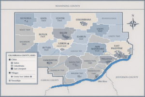
Columbiana County Zoning Map Overview
How to Access Columbiana County Zoning Maps
Zoning authority in Columbiana County is handled at the township and municipal level, but the Columbiana County Auditor’s Geographic Information System (GIS) provides parcel maps, zoning overlays (where available), and property details.
You can view zoning related information by searching:
- Parcel number
- Property address
- Owner name
Steps to Access the Map
- Visit the Columbiana County Auditor’s GIS portal.
- Enter a parcel number or address.
- View parcel boundaries, property details, and available zoning layers.
- Use the map legend and township zoning codes to interpret your district.
For full zoning rules, refer to your specific township zoning department, as zoning is not centralized county-wide.
Reading Zoning Map Codes and Colors
Zoning maps use colors and abbreviations to identify land-use categories. Codes vary by township, butcommon Columbiana County zoning designations include:
- R-1, R-2, R-3: Residential zoning (single-family, two-family, multi-family)
- C-1, C-2: Commercial business districts
- I-1, I-2: Industrial/manufacturing districts
- A or AG: Agricultural / rural residential
- OS or CON: Open space, conservation, protected areas
Always refer to the legend and your township zoning resolution for exact definitions.
Types of Zoning Districts in Columbiana County
Residential Districts
Residential zones regulate housing density, building types, lot size, and accessory structures.
Examples:
- R-1: Single-family homes with larger lots
- R-2: Two-family or duplex housing
- R-3: Multi-family apartments or townhomes
Regulations may include rules for fences, garages, sheds, and building height.
Commercial & Industrial Districts
Commercial districts (C-1, C-2) allow retail, offices, restaurants, and service businesses with rules for:
- Parking standards
- Traffic access
- Lighting and signage
Industrial districts (I-1, I-2) allow:
- Warehouses
- Manufacturing facilities
- Distribution centers
These zones follow environmental and noise control standards.
Agricultural & Rural Districts
Agricultural zones protect farmland and support rural living.
Common permitted uses:
- Crop farming and livestock
- Greenhouses
- Farm dwellings
- Barns, silos, and agricultural facilities
Some townships may restrict residential subdivision in AG districts.
Zoning Regulations and Permits
Before Building or Renovating
Before starting construction, always confirm:
- Your property’s zoning district
- Setback requirements
- Height limits
- Accessory building rules
- Whether you need a zoning permit, variance, or conditional-use permit
Each township or municipality (e.g., St. Clair Township, Fairfield Township, Center Township, Salem City, Lisbon Village) has its own zoning inspector and approval process.
Applying for a Zoning Change or Variance
Variance
A variance allows you to deviate from a specific zoning rule (e.g., reduced setback, smaller lot width).
Rezoning
A rezoning request seeks to change your property from one zoning classification to another.
Application Steps:
- Contact your township zoning inspector to discuss the project.
- Submit an application with required drawings or site plans.
- Attend public hearings with the Zoning Board of Appeals or Planning Commission.
- Wait for approval before beginning work.
A strong justification and professional site plan improve approval chances.
Conclusion
Understanding Columbiana County zoning maps and regulations helps homeowners, investors, and developers make informed decisions. Whether you’re planning new construction, purchasing land, or starting a business, reviewing zoning details early prevents delays, fines, and legal issues.
For accurate zoning information, visit the Columbiana County Auditor’s GIS portal and contact your township or municipal zoning office. Knowing your property’s zoning today ensures smarter development tomorrow.
FAQs
How do I find my zoning code?
Search the Columbiana County Auditor GIS system and confirm zoning with your township’s zoning office.
Can I run a business from home?
Many residential districts allow home occupations with restrictions. Check specific rules in your township zoning resolution.
What if my property is in multiple zoning districts?
Parcels spanning more than one district may have special limitations. Contact the zoning inspector for guidance before making changes.
Who do I contact for zoning disputes or questions?
Each township, village, and city in Columbiana County has a zoning inspector, planning commission, or zoning board responsible for enforcement and approvals.


Post Comment